|
If you new to cross-country skiing and have questions on what gear to buy or other fundamental aspects of the sport, REI has some great videos that will probably help out. Click here.
0 Comments
While avalanches have not been a big problem on Cedar Mountain, there have been a few incidents over the years and with the increasing popularity of winter sports these days it might be a good idea to learn a little bit about them.
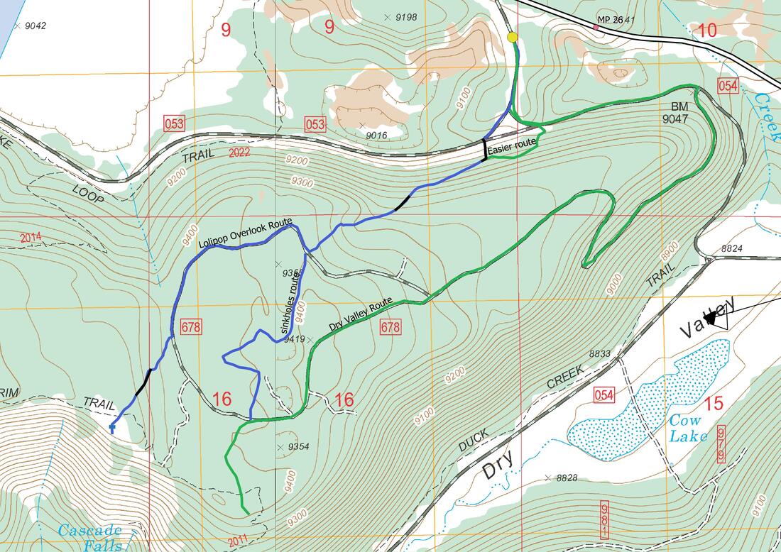
I have included two links that might be helpful (and fun). The first link is to utahavalanchecenter.org/ which has lots of useful and interesting stuff. While they do not, at this time, do forecasts for Southwest Utah they do have a page which has avalanche information for this area. Also I've added a link to a short online avalanche class on general avalanche knowledge that I found on their site. It is very well done, free, about an hour long, and has some great video. I have also added a link to the Utah Avalanche Center to to my CMNSC Quick Info page The Utah Avalanche Center-utahavalanchecenter.org/ Southwest Utah Mountain Information-utahavalanchecenter.org/fore,ast/southwest Avalanche Class-learn.kbyg.org/module/ekbyg Cross-country skiers and snowshoers have not explored this area a lot. The CMNSC has done the "Dry Valley Route" a few times, but has left the rest of the area to still be explored. I have recently discovered a short-cut, a little further to the west, that leads to the top of the mesa. It is much more direct than Dry Valley with fewer ups and downs, but it is also a little more difficult (one of those "you might need skins" sort of routes).
The top of the mesa is mostly rolling hills or flat and has recently been thinned by salvage logging, so getting about is easy. There are several roads you can follow, if you can find them, but for the most part you can ski around anywhere you want. I have skied here several times this year and have seen a few snowmobile tracks, but have never seen or heard them, so I assume the area gets about the same snowmobile use as Deer Hollow. The route I have shown in blue is the way I usually go to get to a beautiful overlook on the Virgin Rim. On this route there are three rather steep hills (shown in black), which, because of the the open nature of the area can be traversed with little difficulty. However, once you get past the second steep hill you are free to wander around as you choose. The short cut to the top of Lollipop Mesa starts at the Navajo Lake winter trail-head (usually plowed) just off SR-14 between mp 25-26. Ski down the road about 500 yd, staying to the right, until you see a small draw to your left. Leave the road here, going left, up the "first steep hill". You'll have to bushwhack for only about 75 yd. to a well cleared logging road. Then turn right, following the road up to a large cleared area. To your left will be a low, very steep, saddle which can be sidestepped, but the easier way (the second steep hill) is to continue traversing up, to your left, just below the ledge, until you come to the bottom a shallow draw, go up and out of the draw (there are many possibilities here pick one you like. You will be on the mesa; many choices from here. Click here for photos |


